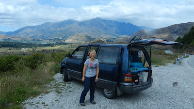
The sands of Abel Tasman to the sounds of Fjordland (Dec-Jan)
 |
| Mosquito Cove in Abel Tasman, only accessible by kayak |
I wound the fishing line back onto its
stick (not a very sophisticated system!) as we headed towards the beach, a sandy lunch spot beneath the
cliffs of one of Abel Tasman's headlands. As expected, nothing was
weighing the hook down, again, and it clattered onto the deck,
immediately getting caught and tangled. After our beginner's luck
fishing in the Marlborough Sounds, this time we'd made the mistake of
packing a frying pan and a lemon in our kayak - clearly a bad omen. There weren't even any mussels here, so it would be back to
dried packs of pasta. Never mind, any food tastes pretty good when
it's cooked on a beach and you're hungry from paddling!
 |
| Improvised rain shelter! |
Just a few days after we'd finished our
fantastic week kayaking the Marlborough Sounds, we were back on the
water for 3 days to explore Abel Tasman's short but spectacular
coastline. Renowned for its many wide arcs of golden sand framed by
native vegetation, it's one of New Zealand's most popular national
parks. This was early in the season so it wasn't busy, but our
starting town of Marahau still felt like a kayak rental factory,
churning out boats and paddlers each morning after a rather
impersonal 'check in' and briefing where we got taught which way
round to hold the paddle, just in case we'd not worked it out in 10
years of kayaking.. It was very different from anywhere we'd rented
boats from before, but as soon as we were out on the water we could
forget all that and enjoy the scenery. The coast was
lovely to paddle around, with lots of rocky headlands where seals
lounged and little islands to circumnavigate, and plenty of sandy
spots to rest and enjoy the view. We got up early and stayed out late (ignoring the company's imposed 4 pm paddling curfew..), and were rewarded with the coast at its calmest, quietest and most beautiful.
 |
| Exploring a lagoon |
An unexpected highlight was the tidal
lagoons that could only be entered by kayak over their sand bars at
high water. They led us inland through calm, reed lined
estuaries and up river until the water became too shallow to continue and we'd feel the crunch of the hull grounding. In the evening these lagoons
were very peaceful, just the drips of water from our paddles
interrupting the reflection of the bank, where kingfishers and herons stared at us from their fishing perches. There are times when a kayak feels like the best place to be in the world.
 |
| Paddling in the morning calm |
 |
| Flower filled Cobb Valley |
Chatting with another paddler at our
beach side camp one evening, he recommended tramping in the Cobb
valley, a fairly remote area of the nearby Kahurangi National Park. So when we left our kayaks (briefly wondering if the company would
even have noticed if 'no 34' didn't return?..) we headed inland. Cobb
was a wide, open and alpine flower filled valley that led up river
for 8 miles or so to the cosy Fenella hut, perched on the edge of the
wilderness. It was a beautiful spot to dry out after kayaking and get
back into tramping. As is usual here, although the hut was a social little hub of tramping and travel talk, we saw no-one else
on the path for 2 days and felt like we had the whole national park
to ourselves. From the hut an easy day trip took us up Kakapo Peak, a
nearby mountain with expansive wilderness views of rocky ridges and
forest. It was hot work, but there was a lovely tarn to cool off in
before we headed back down the valley.
 |
| Tarn swimming |
 |
| Kahurangi wilderness scenery |
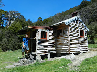 |
| The lovely Chaffey Hut |
On our walk in we'd passed the
Chaffey Hut, a very cute, beautifully renovated, historic little hut by the
river. We'd fallen in love with it and decided to spend the night before we left the mountains. Definitely our favourite place to stay in New Zealand, Chaffey
has just 2 bunks and a fireplace, and is the perfect spot to fulfill
any woodcutter's cottage fantasies (?!), perched above a swimming hole in the river and with views up valley to the hills beyond.
 |
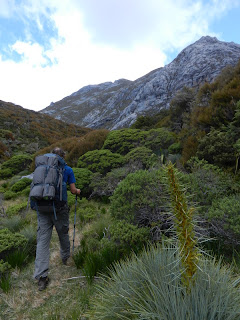
| Rock crevasses on Mount Owen |
The early December weather was perfect,
so we moved straight onto our next tramp- a climb of Mount Owen. This
is a unique mountain in Nelson, covered in classic
limestone scenery with huge clints and grykes forming massive rock
crevasses between slabs. The place is riddled with sink
holes packed with ferns, mosses and alpine flowers, and the weirdly
shaped cliffs and boulders are etched with deep grooves. It's a scrambler's playground, and after
a long, hot and steep walk in we spent the best part of 2 days
exploring the mountain system. There was another really good hut to
stay in, modern this time, and yet again we met no other trampers on the route.
The mountain rises above fantastic, colourful and exotic vegetation
including some vicious speargrasses with huge thorned flowers.
 |
| Spiky speargrasses on Mount Owen climb |
It all
had a feeling of a lost world, and it's easy to understand why the
mountain was chosen to represent 'Dimrill Dale' in the Lord of the
Rings films (although everywhere here seems to have featured in the films at
some point or other). From the summit was the grandest view we'd had
yet and it certainly made us realise just how mountainous this
country is. Ridge after ridge, too many peaks to count, and spreading
in every direction from the coast in the north to the distant
Southern Alps. We could spot Nelson Lakes, the Kaikoura range and a
few other places we'd visited, but most of the view was new to us and
it was very inspiring. You'd need more than a few years and a
helicopter (or a love of bush-whacking) to reach them all, but the
possibilities are endless. Later that day we got down to the
valley floor and a much anticipated swim in the river. It was deep, clear
and blue-green, swirling between smoothly carved rocks and very
scenic, but absolutely infested with sand flies. A whole new
motivation to get in the water and stay in- they were biting any
exposed skin and were the worst we'd experienced. Just like the midges in scotland or the mosquitoes in the
tropics- there has to be an insect around to spoil things!
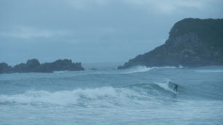 |
| I wonder why Karl's the only surfer out at Cape Foulwind? |
Moving on to the West Coast- with a reputation for
rain, wind and wild weather. As soon as we arrived it started to
show us just how miserable it could be. Karl braved the big, cold
surf at the aptly named Cape Foulwind, but mostly we waited for the
weather to improve, whiling away some time visiting the functional
towns of Westport and Greymouth and doing our Christmas shopping.
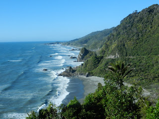 |
| Scenic driving on the West Coast |
It was worth waiting, as a couple of
days later we got to experience the coast road with blue
skies and sunshine- one of the nicest routes we've ever driven. Mile
after mile the road wound around green, verdant cliffs and wide, surf-scoured beaches. We stayed at a village called Punakaikai, famous for
its 'pancake rocks'. Blowholes in the cliffs are surrounded by layered
limestone- like stacks of pancakes turned to stone.
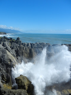 |
| Pancake Rocks blowholes |
All along this coast
gorges cut through the cliffs to emerge at the sea, and it was up one
of these gorges that we headed on our next overnight tramp along the
old 'Inland Pack Route', a path that somehow people used to navigate
before a coast road was built. Most of the route was actually in a
river, with thick bush surrounding the
shallow, pebbly waters and huge cliffs looming overhead.
 |
| The Inland Pack Track |
Once you've got
used to wading in wet boots, it makes sense
to use the river bed as a path, as it is often the only way through the
deep, impenetrable jungle. Our camp was under the 'Ballroom
overhang'- a huge bivvy spot beneath a massively overhanging cliff,
big enough for about 20 tents around the fireplace. Two days of gorge walking certainly gave us a new perspective on the scenery and it was a unique
tramp. Not somewhere to be caught with rising water, so we were very lucky
to fit it into a weather window before the dark West Coast clouds and
driving rain enveloped us once more.
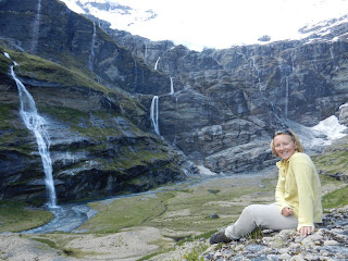 |
| The head of Earnslaw Burn |
Fast forward a couple of weeks
(Christmas on the beach and New Year in Wanaka both covered in a
previous blog) to the extensive Mount Aspiring National Park. We did
a lot of hiking here, both day walks and overnighters. A highlight
was Earnslaw Burn- reached after quite a long slog through forest but
well worth it. At the head of the valley a glacier hung, falling into a
multitude of ribbon waterfalls cascading down the cliffs.
 |
| It was great to see Katy and Dougie again |
We camped below a waterfall with a view of the glacier, and
spent a long time just staring at the scene trying to take it in.
While in the Queenstown area we got a chance to catch up with Katy and
Dougie, a couple we met in a bakery in Namche
Bazaar, high in the Himalayas. At the time, like us Katy and Dougie had been at the start of a world trip, but have now decided to settle here rather than return to the UK (we might be
just a little bit jealous..). Although Queenstown is in a beautiful lake side
setting, the town itself is crammed in between the shore and the steep hills, and is very busy and touristy. Traditionally
this is somewhere you spend quite a lot of money- usually on
adrenaline activities, but in our case it was much less exciting- handing over $500 in the garage for a new shock after numerous rough
roads and river fords had taken their toll on our van's suspension.
Ouch.
 |
| Scenery of Queenstown- us and our van are about to get a shock |
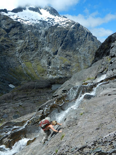 |
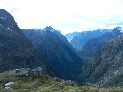
| The climb up to Gertrude Saddle |
Leaving Queenstown we drove south to
Fjordland, one of the biggest national parks in the world. Very
little of Fjordland is accessible, which just adds to its appeal. The prize for New Zealand scenery just
has to go
to a little spot in the mountains above Milford Sound, modestly named Gertrude Saddle.
Douglas Adams put it well in his book 'Last
Chance to See'; 'Fjordland is one of the most astounding pieces of land anywhere on God's earth, and one's first impulse, standing on a cliff top surveying it all, is simply to burst into spontaneous applause'. That's
exactly how we felt here. Why hadn't anyone told us about this place?
It seemed like the sort of spot people should make pilgrimages
to. As it was, it was just us and a few other trampers dotted around,
each having our own 'wow' moments.
 |
| Our camp at Gertrude Saddle (our tent's on the left). |
We'd climbed up a U shaped valley surrounded by glacier scoured curving slabs, passing deep, clear tarn waters and tumbling waterfalls, and up steep, gritty rock to the saddle itself. Here it suddenly all
dropped away- 1000 metres away, with immense cliffs over which waterfalls streamed down to the forest and river
far below. At the end of the valley was Milford Sound, framed by
mountains and looking far, far below. Above us the tarn dotted ridge led over bulging slabs of gabbro rock up the steep and snowy summit of Barrier Knob.
The saddle was an amazing
vantage point, and we were very glad to be able to pitch our tent and
stay up there, exploring the ridge and taking in the view one way,
then the next, then back to the first again. There was just too much
to take in, too much beauty to process. It sounds over the top, but
it was a real high point of our travels. We couldn't stop grinning. It's moments like this we travel for, and we felt it was worth coming all the way around the world just to be here. And there wasn't even a single sand fly!
Harriet


No comments:
Post a Comment